Top 10 Things to See at Capitol Reef National Park
- Dustin Cook

- Feb 20, 2021
- 7 min read
Updated: Nov 17, 2022

Capitol Reef National Park is the least visited of the "Mighty 5" National Parks in Utah. In fact, I still run into many Utahns who have yet to visit this geological treasure located in almost the exact center of the state. In many ways, the lack of crowds compared to Arches and Zions National Park make a trip to Capitol Reef more special. Many people don't add Capitol Reef to their itinerary because they aren't sure what the park has to offer. Whether you are visiting out of state or are a local Utahn who just hasn't made the trek to Capitol Reef yet, here are the top 10 things to see and do in the park.

10. Pie at the Gifford House - I've never been to Capitol Reef without stopping by the historic Gifford House near the Fruita Orchards and having fresh baked pie. This old farmhouse has been converted into a quaint gift shop, but of all the things for sale, I think the pie is the best. They even sell homemade ice cream to go on top if that is your thing. Make sure to go early however, it is not uncommon for the Gifford house to sell out of pie, or at least the best flavors by lunch time. I always begin any adventure in Capitol Reef with pie from the Gifford House. You can enjoy it on the Picnic tables and take in the incredible views as you fuel up for your adventure.

9. Cathedral Valley - It's off the beaten path and down a long dirt road, but the unique sandstone formations of Cathedral Valley are definitely worth the drive. Looking like sandstone cathedrals in the desert, it's not hard to understand how this valley got it's name.
To reach Cathedral valley, take the Hartnet Road East of Orientation Pullout. A sign marks the road and the trail starts by fording the Fremont River. I recommend only driving this trail with a truck or SUV - the road does not require any crazy off road driving skills or a huge suspension - I did it in a stock Tacoma - but is definitely nice to have the clearance and 4 wheel drive for the river ford and for a few spots where the road is rough.
From the viewpoint of Cathedral Valley on the Hartnet Road you can head north down into the valley and take a right at Cathedral junction into Cathedral Valley. The road will take you through the valley and passed the Temple of the Sun and the Temple of the moon before reaching the town of Caineville outside of the park boundary. Allow a few hours to complete the entire loop and it's always a good idea to check at the visitor center for current road conditions and depth of the river.

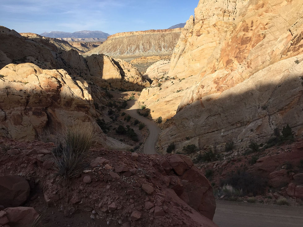
8. Panorama Point - Located at the west entrance of the park, just off the main road Panorama Point provides some great views of the geologic formations that give Capitol Reef its name. Capitol Reef gets its name from the white sand stone domes that look like the domes of Capitol buildings and the rocky cliffs that are a barrier to travel like an ocean reef. Other points of interest near Panorama point are Chimney Rock and Gooseneck overlook so if you are going to stop for one, it is worth hitting them all.

7. Petroglyph Panel - Keep left on Highway 24 as you pass the visitor center and just beyond the old school house is Petroglyph Panel along the Fremont River. A wooden walkway hugs the sandstone cliff and allows for an up close view of many different petroglyphs. The walk itself is only a few hundred yards, but provides a glimpse into the rich history of the Capitol Reef area. It is also a great place to get out of the summer sun and enjoy the cool breeze of the river and shade of the trees.

6. Temple of the Sun & Temple of the Moon - These are two unique sand stone formations just barely inside of the park boundary. What makes these two unique is the flat landscape and lack of any other rock formations around them. To access the Temple of the Sun and Temple of the Moon take the Cathedral Valley Road that heads north from Caineville. It is about a 15 mile drive out to the two Temples and the road takes you right up to each of them. The Cathedral Valley road is a dirt road and its condition can be greatly affected by weather. Plan on a couple of hours for an out and back trip to the two temples. I would recommend only attempting the road with a truck or SUV, especially if weather conditions are not ideal. For more information, check out this article.

5. Scenic Drive to Capitol Gorge - This scenic drive begins just past the Fruita campground and extends 8 miles to Capitol Gorge. The road is paved and while it is a relatively short journey it is packed with some great scenery. The road hugs one of the large sandstone "Reefs" that contributes to Capitol Reef's name and ends at the scenic spot Capitol Gorge. Along the scenic drive is Grand Wash, which is a great canyon to get out of the car and explore and is also the starting place to the popular Cassidy Arch Hike. I've done the scenic drive by car and by bike and however you choose to experience it, you won't soon forget it.
4. Hickman Bridge Hike - The trail to Hickman Bridge is just under 1 mile each way and gains about 400 feet in elevation. It is rated as moderate by the National Park Service. The hike itself goes under and round the 133-foot natural bridge and provides some good views of the canyon. This is a good hike for families even though it is rated moderate, as the trail is wide and not exposed at any parts. The trailhead is located on the North side of Highway 24 just east of the Petroglyph Panel. The turnoff is well marked and there is parking available off the road. For a guide to many of the hikes in Capitol Reef, click here.

3. Burr Trail Switchbacks - The Burr Trail Switchbacks are an interesting part of what is known as the Burr Trail, a trail system that extends from Capitol Reef across Grand Staircase and the Glen Canyon Recreation Area. The Burr Trail was named after John Atlantic Burr, who settled this area in 1876 and used it for grazing cattle.
The switchbacks are one of the few passages across the Grand Staircase area of Utah and are made up of hairpin turn switchbacks that quickly ascend up a sandstone canyon. The switchbacks are steep by today's standard and make for one of the best stretches of scenic highway in Utah.
In dry conditions the switchbacks are passable by passenger vehicles and provide excellent views of the Water Pocket Fold area below as you ascend the switchbacks. In wet or mixed conditions, 4-wheel drive is recommended. The Burr Trail switchbacks can be accessed from the Notom-Bullfrog Road in Capitol Reef National Park or from the Burr Trail road in Boulder Utah.
The Notom-Bullfrog Road is a dirt road that parallels the Water Pocket fold south passing a few back country campsites and various hikes and side canyons. It can be a bit bumpy, especially in a passenger car, and is very remote, so be sure to have plenty of gas and water. You'll follow the road south for 33 miles from Orientation Pullout in Capitol Reef and then head west on Burr Trail Road. Just after turning on to the road you'll see the switchbacks. You can check current road conditions here.
Soon after the switchbacks the road turns to pavement and takes you through a stunning part of the Grand Staircase Escalante National Monument. The road ends at Highway 12 in Boulder at one of the best burger and pie places in Utah - the Burr Trail Grill. If burgers aren't your thing Hell's Backbone Grill is just up the road and has excellent food and more choices. I recommend starting in Capitol Reef and driving up the switchbacks to Boulder, but for those who want to avoid driving on dirt roads you can do an out-and-back trip from Boulder to the switchbacks limiting your time on an unpaved road.

2. Cassidy Arch - Perhaps the most iconic hike in Capitol Reef is Cassidy Arch, named after the famous outlaw Butch Cassidy who used areas like Canyonlands, Capitol Reef and Grand Staircase Escalante to avoid the law. Cassidy Arch climbs 670 feet up a mesa in just over 1.7 miles. During the hike, the Arch comes into view from a distance with the hike ending at the arch itself. At the end of the hike you are essentially looking down and into Cassidy Arch. While it is marked strenuous, many hikers can handle this hike due to its relatively short length.

While the arch marks the end of the trail for most, for a few this is just the beginning. Cassidy Arch is also a popular canyoneering route that begins at the arch. Substantial technical equipment is needed to descend this canyon as it starts off with two 150 foot rappels back to back, so you'll need plenty of rope. After the first two rappels the remaining rappels are relatively short and the Canyon opens up to more hiking and down climbing. This is a dry canyon and can be completed in a few hours. I recommend consulting a guide book before attempting the canyon.

1. Camping at the Fruita Campground - Capitol Reef has a lot to offer, but my all time favorite thing to do at Capitol Reef is to camp at the Fruita campground. The campground is located around the historic fruit orchards of Capitol Reef along the Fremont River. Many refer to Fruita as an oasis in the desert with its green grass and plentiful fruit orchards. From the campsite you also have great views of the sandstone mesas of Capitol Reef as it is the start of the scenic drive to Capitol Gorge.
Getting a campsite here can be a challenge, especially from March to the end of October. Even though it has 71 sites for both tents and trailers/RVs the campground fills fast. You can make reservations in advance at recreation.gov to secure your spot, which I highly recommend. There are ranger talks just about every night in the amphitheater just through the orchard West of the campground that are fun for families and individuals interested in the geology and history of Capitol Reef. Also Capitol Reef is rated as a Dark Sky area that is ideal for star gazing and night photography.
I hope this gives you some ideas for your next trip to Capitol Reef or motivates you to plan one. If you found this article helpful and are planning other adventures in Utah consider signing up for our e-mail list (simply go to the top of page and click subscribe - it's free!) to get the latest adventure posts. You can also sign up to be a member here to share comments at the bottom of our posts and in our forums. Most importantly don't forget to get outside and find your adventure!


Comments